© The Indian Express Pvt Ltd
Journalism of Courage

 Having now experienced an early arrival, Mumbai can expect above normal showers this monsoon season. (Express photo: Sankhadeep Banerjee)
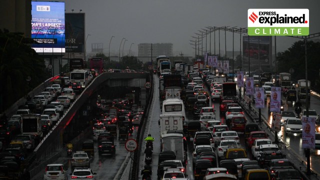
Mumbai Monsoon Start Update 2025: Mumbai woke up to an unusual Monday in what has been an unusual May — monsoon arrived two weeks in advance, and in full force. Life was thrown out of gear in the maximum city as several pockets reeled under water logging, traffic and slow train services.
This year’s monsoon onset has shattered all-time records. Data show that this is the earliest that the monsoon has ever arrived in Mumbai (IMD has been keeping records since 1950), with the previous earliest onset date logged at May 29 in the years 1971, 1962 and 1956. For perspective, the normal date of monsoon onset in Mumbai is June 11.
Typically, monsoon onset in Mumbai is nearly 10 days after the arrival of rains in Kerala. The normal date of onset in Kerala is June 1, following which the southwest monsoon typically advances to Maharashtra by June 6 and then onto the Mumbai coast by June 11.
This year, the India Meteorological Department (IMD) announced the onset of monsoon in Kerala on May 24, the earliest since 2009. Also, the southwest monsoon travelled from Kerala to Maharashtra within 24 hours, reaching Maharashtra on Sunday and Mumbai on Monday.
According to Shubhangi Bhute, director of IMD Mumbai, the early onset and fast progression were spurred by “very favourable” conditions.
Senior meteorologists pointed to the active Madden-Julian Oscillation (MJO) as a crucial contributing factor. MJO originates in the Indian Ocean and is one the most important factors influencing Indian monsoons.
The MJO is basically a complex, moving system of winds, clouds and pressure. It travels eastward at the speed of 4-8 metres per second. Within 30 to 60 days, MJO wind bands can travel around the world and cause significant weather changes in their wake. In favourable phases, they can enhance monsoon rainfall over India.
In its extended range forecast issued on May 22, the IMD had said that the MJO was then in Phase 4 with an amplitude greater than 1, which is indicative of strong rainfall and storms.
“While the favourable MJO is one contributing factor, the cross equatorial flow (which carries heat and moisture between the Northern and Southern Hemispheres) is also very strong at the moment. This further brings in a lot of moisture,” added an IMD official.
Further, a low pressure area in the Arabian Sea, which developed owing to a cyclonic circulation, also aided the fast movement of the southwest monsoon, IMD scientists said. It was this low pressure area that had brought in heavy pre-monsoon showers in Mumbai over the past few weeks.
In what has made this month Mumbai’s wettest May in the past 107 years, the IMD’s Colaba observatory has recorded 295 mm rain so far this month. Prior to this, the heaviest showers in the island city had been recorded in May 1918 at 279.4 mm. Meanwhile, having already received 197 mm rain this month, this is also Santacruz’s rainiest May month since 2021.
Thanks to the heavy rain spells, heatwaves — a typical phenomenon during May — have eluded the city this year. In fact, earlier on May 8, Mumbai woke up to its coldest May morning in more than 70 years. The minimum temperature dipped to 22.2°C as per the Colaba coastal observatory, which is the coldest day recorded in the island city since 1951.
The early monsoon onset has come at a time when Mumbai is already reeling under a surplus of over 700 per cent from the actual normal rain for the month of May.
Not only the metropolis, but the entire state of Maharashtra, is experiencing an unusual May, with Buldhana district logging a rain surplus of over 4,000 per cent from its actual long period average for the region. Coastal districts like Sindhudurg and Raigad have recorded surplus of over 2,600 per cent and 2,000 per cent respectively so far.
Mumbai can expect above normal rain this monsoon.
The IMD had said in its long-range forecast that this year, the country is expected to experience above normal monsoon, which is forecast to be “105% of the Long Period Average (LPA) with a model error of ± 5%”.
Long period average is the average rainfall recorded in a region in a specific period (like a month), calculated over 30 or 50 years.
The Met Department has pointed out that the neutral El Niño Southern Oscillation (ENSO) and the Indian Ocean Dipole (IOD) conditions, slated to prevail during the monsoon, will contribute to a bountiful season.