© The Indian Express Pvt Ltd
Journalism of Courage

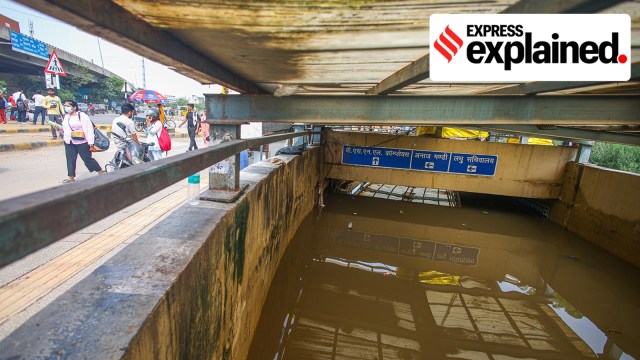 Gurgaon monsoon flooding: A flooded underpass at Rajiv Chowk in Gurgaon last week. (Praveen Khanna)
Gurgaon monsoon flooding issues: The Delhi Master Plan of 1962 saw Gurgaon (Gurugram) as a place of modest urban growth, primarily because the area has no groundwater resources. In 1980, with Maruti setting up its factory in Manesar, Gurgaon emerged as an industrial hub.
A decade later, with liberalisation and the promise of rapid economic growth and infrastructural development, the mythical village mentioned in the Mahabharata became India’s Millennium City, a model for 21st century urbanisation in India — and everything that is wrong with it.
 Every monsoon, Gurgaon witnesses extreme flooding: hours-long traffic jams, cars floating in the deluge, and people being electrocuted are common occurrences. All this happens even though Gurgaon receives only about 600 mm of rain on average every year. In comparison, Kochi receives well over 3,000 mm of rain annually without going under every monsoon.
What makes Gurgaon, home to nearly 2 million people and boasting the third highest per capita income among cities in India, this vulnerable to monsoon flooding?
The Aravalli ridge, on the southern edge of Gurgaon, is the natural high ground for the city. From there, the land slopes down towards the north, which is at a lower altitude. Rainwater in Gurgaon thus flows mainly from the south to the north, towards the Najafgarh Jheel in West Delhi.
Maps from the 1920s show a large number of water channels in Delhi-NCR. The ones in Gurgaon ran along an east-west axis. “Before MG Road and Sector 56 came up, there were water channels that ran parallel to the Aravalli ridge,” architect-urban designer Suptendu Biswas told The Indian Express.
These were natural drainage channels, which carried runoff towards what is now the western edge of Gurgaon, from where water would travel further north. But these channels have all but disappeared, and subsequent urban expansion has not kept the city’s topographic reality in mind.
Today, Google Earth images show arterial roads like the Golf Course Road run on a north-south axis — this makes them ideal routes for surface runoff, especially given that drains are non-existent or poorly planned. “Topography was not only ignored but also abused,” Biswas said.
One reason why urban expansion in Gurgaon has not kept up with topographic realities is the piecemeal nature of city planning. This is borne out of the city’s unique land acquisition model which is central to Gurgaon’s growth story.
From the 1970s onwards, the Haryana government introduced a series of laws, which enabled private firms to acquire land on a large scale to develop townships. The Haryana Urban Development Authority (HUDA) was created in 1977 to streamline the process.
Having developed neighbourhoods such as South Extension and Kailash Colony in Delhi, Delhi Land and Finance (DLF) alone acquired 52 villages in the initial years from farmers. As other players came along, land acquisition was not carried out in a uniform manner. This led to irregular plots, and roads that led to nowhere.
“Allocative decisions form the very core of conventional urban planning, which was missing in Gurgaon’s story from the beginning,” Biswas wrote in Gurgaon to Gurugram: A short biography (2021).
The “plug-and-play” mode of urban expansion meant that roads were not built with proper gradients, nor was there any big picture thinking behind basic planning decisions for the city.
In Gurgaon, mustard fields have long made way for highways and highrises. A region which once had 60 natural canals, critical to absorb its excess rainwater, barely has four today.
But as concrete, impervious to percolation, has covered Gurgaon, civic authorities have failed to build a robust drainage system to deal with the problem. Concrete drains only add to the flooding due to their inability to absorb water.
According to Biswas, India’s engineering codes have no reference beside steel and concrete — earth is simply not something that planners consider while building a city.
Biswas offered three “common sense” solutions to address flooding in Gurgaon.