Stay updated with the latest - Click here to follow us on Instagram
© IE Online Media Services Pvt Ltd

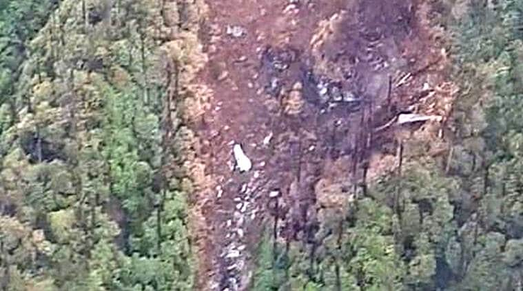 The first visual of the wreckage of the missing AN-32 spotted earlier today in Arunachal Pradesh. (Source: ANI)
After eight days of intense search, the Indian Air Force (IAF) Tuesday located the wreckage of the missing An-32 aircraft deep inside the thick jungles of Arunachal Pradesh. The first image of the crash site, shared by news agency ANI, shows debris scattered around the area and charred trees seemingly due to the fire following the crash.
The IAF confirmed that the wreckage was spotted 16 km North of Lipo, North East of Tato at an approximate elevation of 12000 ft by its Mi-17 chopper, which was undertaking the search in the expanded search zone. It also stated that efforts are underway to establish the status of occupants and establish survivors.
The aircraft carrying six officers, five airmen and two non-combatants (enrolled) took off from Jorhat in Assam at 12.27 pm on June 3 for the Mechuka Advance Landing Ground in Arunachal Pradesh, where it was supposed to reach at 1.30 pm. The weather over the region was turbulent on the day and the aircraft’s last contact with ground agencies was at around 1.00 pm.
The Mechuka Advance Landing Ground is located in Mechuka Valley in West Siang District of Arunachal Pradesh. It is the closest landing ground to the India-China border nearing the McMohan line.
The IAF launched a massive operation after the aircraft went missing but the search was badly hit due to poor weather conditions. The assets deployed for the operation included Sukhoi-30 aircraft in addition to a fleet of C-130J and AN-32 planes and Mi-17 and ALH helicopters.
The ground forces included troops from the Army, Indo Tibetan Border Police and state police.
ALSO READ | An-32 wreckage spotted in Arunachal: IAF says efforts on to establish survivors
The Indian Navy’s P-8I aircraft was also deployed earlier this week as it has electro-optical and infra-red sensors which could be helpful in the search operation. ISRO’s Cartosat and RISAT satellites were also used to take images of the area around Menchuka.
Stay updated with the latest - Click here to follow us on Instagram