


Traffic snarls across Delhi-NCR as rain leads to waterlogging
Heavy rains in several parts of Delhi and NCR led to waterlogging and traffic jams on Thursday, with parts of NH 48 in Gurgaon being inundated.
According to the India Meteorological Department, moderate rainfall is expected on Friday, Saturday and Sunday and the department has issued a ‘yellow alert’ for Friday. A yellow alert is a warning to be aware that moderate to heavy showers are expected.


Waterlogging on multiple stretches caused by intermittent rain for the third consecutive day led Gurugram Traffic Police to issue an advisory about diversion and congestion.
"Commuters on NH8 from Delhi/Gurugram to Manesar, Rewari and Jaipur side are requested to follow alternate routes like Golf course extension, Vatika Chowk and SPR," Gurugram Traffic Police said in its advisory on Twitter.
"Similarly inner city commuters may follow Rajiv Chowk to Vatika Chowk and SPR route. This way will be free from water logging and they will be able to avoid slowdown of Traffic at Narsingpur water overflow/logging on Highway and service lanes. Traffic police will be there to facilitate your easy flow."
More than 50 areas, including Sector 15 Part 2, New Colony, Sector 7, Golf Course Road, Golf Course Extension, Service Lane of Delhi-Gurugram Expressway to Kherki Daula, Sector 10, Village Khandsa and Manesar, have been affected by the waterlogging.
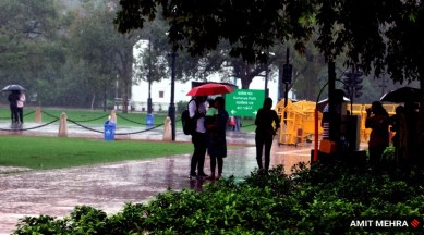
Rains continued to lash Delhi for the third consecutive day on Saturday causing traffic snarls at some places in the morning, even as the minimum temperature settled a notch above the normal for the season.
The city received 15 mm of rainfall from 8.30 AM on Friday to 8.30 AM Saturday, according to data shared by the India Meteorological Department (IMD). (PTI)
Parts of Mumbai witnessed heavy rains on Saturday, but the public transport services in the city remained unaffected and no major waterlogging was reported, civic officials said. (PTI)
In what is set to be a rainy weekend for Delhi, overcast skies and moderate rainfall are likely to persist in Delhi-NCR on Saturday along with the possibility of heavy rainfall in a few places.
Saturday is set to be the third consecutive rainy day for Delhi-NCR. Know more...
Heavy rains has caused damage to the standing paddy in many parts of India’s main basmati-growing belt of Haryana – and also led to demands by farmers to sell their crop directly to rice mills bypassing the state-owned APMC (agricultural produce market committee) mandis.
Raghbir Singh, a farmer from Dadupur Roran village of Karnal district and tehsil, had only three days back harvested two out of his five-acres land planted under the early-maturing Pusa-1509 basmati paddy. He was quite buoyant, as this paddy variety was fetching Rs 3,500-3,600 per quintal, as against Rs 2,800-2,900 at the same time last year. But he couldn’t sell the harvested crop due to read more
The local forecast for Bengaluru predicted generally cloudy skies and the possibility of light rain today.
The weather forecast for Mumbai predicted a partly cloudy sky in the morning ; a generally cloudy sky towards evening with light to moderate rain in city and suburbs.
Further withdrawal of the Southwest monsoon from more regions along the northwestern parts of the country is not expected at least for another five to seven days, officials of Indian Meteorological Department (IMD) said on Friday. Know more here
Former Haryana Chief Minister Bhupinder Singh Hooda on Friday demanded compensation for the farmers as “thousands of acres of crops across the state have been submerged due to the rains since the past two days”.
“Every farmer has suffered a loss of thousands of rupees due to the destruction of the standing paddy crop. Due to waterlogging, all the crops standing in the field, including paddy, have been affected. In such a situation, the government should immediately get girdawari done and give compensation to the farmers,” he said. Read here
Two weather systems coinciding brought heavy rainfall to Delhi-NCR at the fag end of the monsoon season, after what was a mostly dry August and September.
The heavy rainfall spell that began on Thursday and extended into Friday was only the second such heavy spell for the southwest monsoon season in Delhi so far. The first such heavy spell was recorded when the monsoon hit Delhi on June 30. Know more here
In view of the "yellow alert" being issued by the India Meteorological Department (IMD) for Delhi on Saturday and Sunday, the Delhi Development Authority (DDA) has decided to postpone its "Tree Walk" event from September 24 to October 8.
Delhi recorded more than half of the rainfall of September in just 24 hours, swinging from being rain deficient to rain surplus.
The Safdarjung Observatory recorded 58.5 mm of precipitation against a normal of 108.5 mm between September 1 and September 22.
However, Delhi received 72 mm of rainfall in the past 24 hours. Normally, the national capital records 125.5 mm of rainfall in September.
Rainfall recorded below 15 mm is considered light, between 15 and 64.5 mm moderate, between 64.5 mm and 115.5 mm heavy, between 115.6 and 204.4 very heavy. Anything above 204.4 mm is considered extremely heavy rainfall.
The weather bureau has attributed the heavy rain to the interaction of a Western Disturbance and a low-pressure system.
(PTI)
The Indian Meteological Department (IMD) predicted that isolated heavy falls & thunderstorm/lightning are very likely over Uttarakhand during September 23 to September 26; Himachal Pradesh and West Uttar Pradesh during September 23 to September 25; Haryana, Chandigarh and East Rajasthan on September 23 and September 24; East Uttar Pradesh on September 25and Delhi & West Madhya Pradesh on September 23.
A marginal drop in the Kharif crop output due to uneven distribution of rain this monsoon season is unlikely to impact food security or drive inflation up as India has enough reserves, agriculture and food policy experts have said.
They, however, said farmers, at the individual level, have been hit the hardest by the highly erratic monsoon and many have not yet received help from state governments. (PTI)
Friday marks the autumn equinox in the northern hemisphere, an astronomical event resulting in an equal duration of day and night on this particular day.
The earth’s axial tilt and its relative position in its orbit of rotation around the Sun give rise to seasons like summer or winter. According to the Astronomical Society of India, there are two equinoxes in a year, during which the Sun’s rays falling on the Earth are perpendicular to the Earth’s axis. It is also that time of the year when the Sun crosses over the equator either to the northern or the southern hemisphere. Read more...
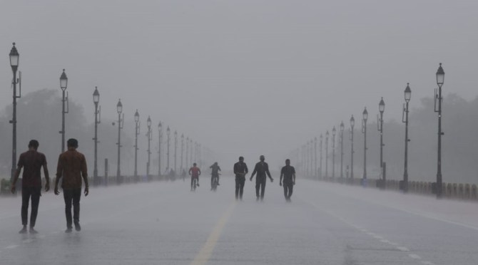
After rainfall through the night and early Friday morning, overcast skies and moderate rainfall with thundershowers are set to persist in Delhi on Friday. The India Meteorological Department (IMD) has issued a ‘yellow’ alert for Friday, which is a warning to ‘be prepared’. The impact expected on Friday, according to the IMD, is major traffic disruptions, increased chances of accidents and waterlogging in low-lying areas.
The maximum temperature is likely to settle at around 28 degrees Celsius on Friday, below the normal of 34 degrees Celsius for this time of the year. Know more here
The Meteorological Centre's local forecast predicted the possibility of light rain in the next 48 hours for Bengaluru city.
On Tuesday (September 20), the American meteorologist Vernon Dvorak passed away at the age of 100. In the era of advanced satellite technology, Machine Learning (ML), Artificial Intelligence (AI), this key technique, named after him, continues to be widely relied upon by forecasters till date. Read more about the technique here
At least 10 people were killed, seven of them in Etawah, and 11 injured in incidents of lightning, and wall and house collapses as heavy rains in parts of Uttar Pradesh affected normal life in Firozabad and forced the closure of schools in Aligarh. Know more here
Mumbai woke up to rains Thursday morning as heavy to moderate rainfall was recorded in both the island city and its suburban belts.
Indian Meteorological Department (IMD) officials, however, denied the chances of any heavy rainfall in the city and said that light to moderate spells of rain would continue to lash it for the next 48 hours. Read more...
The Australian Bureau of Meteorology on Tuesday (September 13) confirmed the occurrence of La Niña phenomenon for the third consecutive year in the Pacific Ocean. The World Meteorological Organisation (WMO) on August 31 had stated that the oceanic and atmospheric phenomenon would last until at least the end of the year, and for the first time this century, span three consecutive northern hemisphere winters to become a ‘triple dip’ La Nina.
The WMO predicted that the current La Nina, which began in September 2020, would continue for six months, with a 70 per cent chance of lasting till September-November 2022, and 55 per cent chance of lasting till December-February 2022/2023. What are El Nino and La Nina? We explain
Heavy rains on Thursday and forecast of more in the coming two to three days had resulted in schools being shut in Noida and Greater Noida for Classes I to VIII.
The District administration of the Gautam Buddh Nagar district declared Thursday that school for classes I to VIII will remain shut on Friday because of the heavy rainfall.
In Gurgaon, meanwhile, all private education institutions have been advised to remain shut. While no advisory was issued, Gurgaon bore the brunt of water logging in the Delhi-NCR region. Several parts of the NH 48, especially the low lying areas were waterlogged. Know more here