Why is the Chagos Archipelago and Diego Garcia a Geopolitical Hotspot for the UPSC Exam?
With British PM Keir Starmer seeking ‘strong protections’ for the US-British base on Diego Garcia, the Chagos Archipelago is back in the spotlight. What is the history of these islands, and why are they a geopolitical hotspot? Also, go 'Beyond the nugget' to learn about other islands that have been in the news.
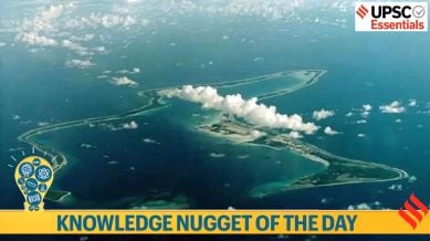
An undated file photo shows Diego Garcia, the largest island in the Chagos archipelago and site of a major United States military base in the middle of the Indian Ocean leased from Britain in 1966 (Reuters/File Photo)
Take a look at the essential events, concepts, terms, quotes, or phenomena every day and brush up your knowledge. Here’s your knowledge nugget for today.
Knowledge Nugget: Chagos Archipelago and Diego Garcia
Subject: International Relations and Geography
(Relevance: Islands that are in the news are significant as UPSC has previously asked questions about places and disputed islands. The Chagos Archipelago and Diego Garcia hold geopolitical and environmental importance, making them important for topics like international relations and strategic locations.)
Why in the news?
On Friday, British Prime Minister Keir Starmer told his Mauritian counterpart, Navin Ramgoolam, that he wants “strong protections”, including from “malign influence”, for a US-British military base on Diego Garcia, according to a statement from Downing Street.
Key Takeaways :
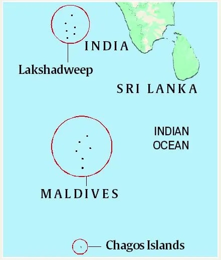
1. The Chagos Archipelago, comprising around 58 islands, is located approximately 500 kilometers south of the Maldives in the Indian Ocean. These islands remained uninhabited until the late 18th century, when the French brought in enslaved laborers from Africa and India to work on newly established coconut plantations. In 1814, under the Treaty of Paris, France ceded Mauritius—including the Chagos Archipelago—to the British.
Map showing Chagos Islands.
2. Britain detached the Chagos Islands in 1965 from Mauritius — a former colony that became independent three years later — to create the British Indian Ocean Territory (BIOT). The UK government gave the Mauritius a grant of 3 million pounds over the “detachment” of the Chagos archipelago.
3. In October last year, Britain reached an agreement to transfer sovereignty of the Chagos Islands to Mauritius while retaining control of the military base on Diego Garcia under a 99-year lease.
You have exhausted your monthly limit of free stories.
Read more stories for free with an Express account.
1. Diego Garcia is the largest island in the Chagos Archipelago, located in the Indian Ocean. In 1966, Britain signed an agreement with the US which made the BIOT available for the two countries’ defence needs. Land was acquired in 1967, and four years later, the plantation on Diego Garcia was shut down.
Story continues below this ad
2. Diego Garcia became a fully operational military base in 1986. An article in Foreign Policy magazine states, “Thanks to its vital location, the island houses a military base that served as a critical node for American air operations during the Gulf War and the wars in Iraq and Afghanistan. Post-9/11, it has also been allegedly used as a detention centre by the [US intelligence agency] CIA.”
“Diego Garcia is the site of a joint U.S.-UK military facility that plays a vital role in national, regional, and global security. It enables the United States to support operations that demonstrate our shared commitment to regional stability, provide rapid response to crises, and counter some of the most challenging security threats we face.” – Former U.S. President Joe Biden said this in October 2024.
3. Notably, Diego Garcia is a coral atoll and southernmost member of the Chagos Archipelago. It is located 7 degrees south of the equator.
BEYOND THE NUGGET: Islands in News
1. Tuvalu: Tuvalu, whose mean elevation is just 2 m (6.56 ft), has experienced a sea-level rise of 15 cm (5.91 inches) over the past three decades, one-and-a-half times the global average. It is a tiny Pacific island nation located halfway between Hawaii and Australia.
Pacific Islands Forum (PIF)
PIF is an intergovernmental organisation which consists of 18 member states located in the Pacific region. It was formed in 1971. The countries of this grouping are among the world’s worst-affected countries due to rising sea levels.The PIF aims to push for economic growth, enhance political governance and security for the region, and strengthen regional cooperation. Pacific Island countries are Australia, Cook Islands, Federated States of Micronesia, Fiji, French Polynesia, Kiribati, Nauru, New Caledonia, New Zealand, Niue, Palau, Papua New Guinea, Republic of Marshall Islands, Samoa, Solomon Islands, Tonga, Tuvalu, and Vanuatu.
2. St Martin’s Island: The ousting of Prime Minister Sheikh Hasina brought St Martin’s Island under the spotlight last year. The island is located in the northeastern region of the Bay of Bengal, close to the border between Bangladesh and Myanmar. It is nine kilometres away from the southern tip of Bangladesh’s Cox’s Bazar-Teknaf peninsula. The 7.3 km long island is mostly flat and sits at an elevation of 3.6 metres above the mean sea level. It is Bangladesh’s only coral island — there are reefs from 10-15 km to the west-northwest — and is also a breeding ground for sea turtles. The island has a permanent population of about 10,000 people.
3. Rottnest Island: A seaplane crashed off an Australian tourist island into the Indian Ocean with three people getting seriously injured and three others remain missing. Seven people were aboard the Cessna 208 Caravan and only one of them was rescued unharmed post the crash at Rottnest Island.
4. Ramree Island: An airstrike by Myanmar’s army on a village under the control of an armed ethnic minority group killed about 40 people and injured at least 20 others. The attack occurred in Kyauk Ni Maw village on Ramree island, an area controlled by the ethnic Arakan Army in western Rakhine state.
5. Kuril Island: Tokyo and Moscow have been locked in a dispute over the Kuril Islands for decades. The Kuril Islands divide the Sea of Okhotsk from the North Pacific Ocean and span northeast from Hokkaido in Japan to the Kamchatka Peninsula in Russia.
6. Easter Island: Easter Island, the most remote inhabited island on the planet, is 3,700 kilometres from the coast of continental Chile in Pacific Ocean and has an area of 16,628 hectares.
Story continues below this ad
7. Tristan da Cunha: One of the world’s most remote inhabited islands, Tristan da Cunha is located in the centre of the Atlantic Ocean and has approximately 250 permanent residents, all of whom are British Overseas Territories citizens.
Roshni Yadav is a Deputy Copy Editor with The Indian Express. She is an alumna of the University of Delhi and Jawaharlal Nehru University, where she pursued her graduation and post-graduation in Political Science. She has over five years of work experience in ed-tech and media. At The Indian Express, she writes for the UPSC section. Her interests lie in national and international affairs, governance, economy, and social issues. You can contact her via email: roshni.yadav@indianexpress.com ... Read More
US President Donald Trump on Monday said the United States is “close to signing a trade deal” with India, after announcing new reciprocal tariffs on 14 countries — including Bangladesh, Malaysia, Japan, Cambodia and South Korea — setting rates at 25 to 40 per cent, and warning that rerouting foreign goods or retaliating would attract even higher US tariffs.
This comes as Indian negotiators are understood to have offered substantial market access to US products in most sectors, excluding sensitive areas such as dairy and agriculture. The US, in turn, is expected to offer lower tariffs on labour-intensive sectors such as textiles and footwear.