

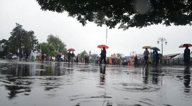

In the last 24 hours, heavy to very heavy rainfall was recorded over Sub-Himalayan West Bengal, Sikkim, Assam, Meghalaya and Mizoram. Light to moderate rains occurred over the rest of the northeastern states. According to Sky Met Weather, light to moderate rain and thundershowers with isolated heavy spells occurred over Jammu and Kashmir, Karnataka, Kerala, Andaman and Nicobar Islands.
Scattered light to moderate rains occurred over Himachal Pradesh, Uttarakhand, Punjab, Haryana, Delhi, North Rajasthan, West and Central Uttar Pradesh, North Madhya Pradesh, North Odisha, Jharkhand, while isolated over East Bihar. The minimums dropped by 2 degrees Celsius to 4 degrees celsius over Northwest India, Jammu and Kashmir, Himachal Pradesh, Uttarakhand, Punjab, Haryana, Rajasthan, West Uttar Pradesh and parts of Madhya Pradesh.


Traffic on the strategic 270-km Jammu-Srinagar National Highway resumed on Saturday evening after being closed for over 13 hours following a massive landslide in Ramban district, officials said. The landslide, triggered by incessant rains over the past two days, occurred near Battery Cheshma around 4.30 am, completely blocking the only all-weather road linking Kashmir with rest of the country, Suresh Sharma, Deputy Superintendent of Police (traffic), national highway Ramban, told PTI.
Light rain and thundershower will continue in southern states for next 2-3 days.
Rain and thundershowers observed at most places over Jammu and Kashmir, Himachal Pradesh, Punjab and Nagaland, Manipur, Mizoram & Tripura; at many places over Uttrakhand, Gangetic West Bengal, Assam & Meghalaya, South Interior Karnataka and Kerala; at a few places over Sub-Himalayan West Bengal & Sikkim, Konkan & Goa and Andaman & Nicobar Islands and at isolated places over Haryana.
In view of the sustained rainfall activity over Andaman & Nicobar Islands, Southwest Monsoon has further advanced
into some more parts of southeast Bay of Bengal and north Andaman Sea, remaining parts of Nicobar Islands and
southern parts of Andaman Islands.
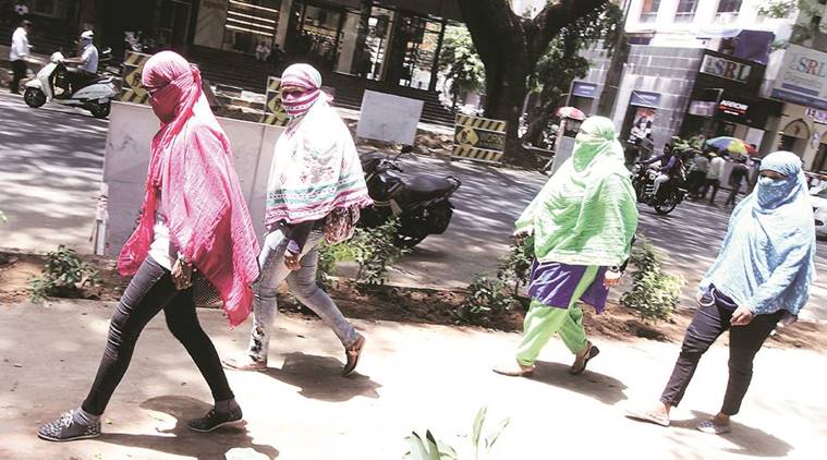
Heatwave conditions in some parts are very likely to continue over Vidarbha and at isolated pockets over Madhya Maharashtra,
Telangana, East Madhya Pradesh, Chhattisgarh, East Uttar Pradesh, Jharkhand and Odisha during next 4-5 days. Strong surface winds (speed reaching 20-30 kmph) are to very likely over parts of south Haryana & Delhi, north Rajasthan, northwest Madhya Pradesh and West Uttar Pradesh during next 24 hours. (IMD)
SkyMet weather predicts duststorm and thundershowers in Punjab, Haryana and Rajasthan.
The weather body predicted mainly clear sky in Ahmedabad. The city recorded a maximum temperature of 42 degrees Celsius and minimum temperature of 29 degrees Celsius.
Chennai recorded a maximum temperature of 36 degrees Celsius and minimum temperature of 29 degrees Celsius.
In Bengaluru, the IMD has predicted partly cloudy sky with one or two spells of rain or thundershowers. The maximum and minimum temperatures stood at 33 and 22 degrees Celsius, respectively.
In Cuttack, the weather body forecast partly cloudy sky with the possibility of development of thunder and lightning. The maximum and minimum temperatures stood at 38 and 26 degrees Celsius, respectively.
In Bhopal, the IMD predicted mainly clear sky. The maximum and minimum temperatures stood at 41 and 29 degrees Celsius, respectively.
In Mumbai, the maximum temperature was recorded at 34 degrees Celsius and the minimum at 27 degrees Celsius.
In Kolkata, the IMD predicted partly cloudy sky with possibility of moderate rain or thunderstorm. While the maximum temperature was registered at 36 degrees Celsius, the minimum stood at 27 degrees Celsius.
On Friday, heat wave conditions were observed in some part of Vidarbha and at one or two pockets over East Uttar Pradesh, East Madhya Pradesh, Marathwada and Madhya Maharashtra.
Meanwhile, an earthquake of magnitude 4.8 on Richter scale hit Andaman islands earlier in the day.
Heat wave conditions in some parts to severe heat wave conditions in isolated pockets likely over Vidarbha during next 1-2 days. Heat wave conditions in some pockets over northeast Madhya Pradesh and in isolated pockets over East Uttar Pradesh, Madhya Maharashtra, Telangana, Marathwada, Chhattisgarh during next 3-4 days and over Jharkhand and Odisha from today, the bulletin said.
Fairly widespread to widespread rainfall with isolated heavy/very heavy falls are likely over Assam, Meghalaya and Tripura during next 48 hours. Under the influence of a Western Disturbance lying over northeast Afghanistan and adjoining Pakistan, fairly widespread to widespread precipitation likely over Western Himalayan region and isolated to scattered rain/thundershowers over adjoining plains during next 24 hours, the weather bulletin read.
The day in Delhi will be marked by mainly clear sky with the maximum temperature expected to hover around 36 degrees Celsius, the MeT official told PTI.
Delhiites woke up to a cool morning today, unusual for this time of the year, with the minimum temperature settling at 24.5 degrees Celsius, two notches below the average. Relative humidity was 53 per cent at 8.30 AM, a MeT department official told PTI.
Heat wave conditions are expected to prevail in some parts over northeast Madhya Pradesh and in isolated pockets over Telangana, Maharashtra, Chhattisgarh, Odisha, Jharkhand and east Uttar Pradesh.
Isolated places in Assam, Meghalaya, Nagaland, Manipur, Mizoram and Tripura are expected to receive heavy rainfall, the IMD bulletin read today.
According to the weather body, thunderstorm and lightning accompanied by gusty winds are also expected at isolated places in south India.
Welcome to our live blog. The Indian Meteorological Department (IMD) has predicted heat wave conditions in certain parts of north and central India while heavy rainfall is likely to hit north east India. Follow this space for latest updates.